Shanna Martin 0:19
Thanks for listening to the Tech Tools for Teachers Podcast, where each week we talk about a free piece of technology that you can use in your classroom. I’m your host, Shanna Martin. I’m a middle school teacher, technology instructional coach for my district.
Fuzz Martin 0:32
And I’m her producer and husband, Fuzz Martin, and I’m just working to put this show on the map. Oh, clever. Yeah. Cute. We’re on the 135th episode.
Shanna Martin 0:44
The Tech Tools for Teachers podcast just got back from Slate. Yeah, how was slay quality time with other teachers and technology. It was fun. It’s been a while since I’ve been there a couple of years off and went back this year. And
Fuzz Martin 0:58
I know you passed out some business cards. So hello to our new listeners from Slate. Hello, hello. Thanks for tuning in.
Shanna Martin 1:06
Yeah, so it was fun. Usually, I my district was just small group. And there was like nine of us this time, and we learned lots of things. And then we’ll go back and present some cool technology and activities and project based learning and SEL and there’s cool stuff with like, PBS and there’s so many things we learned lots of cool things to bring back to our staff. So thank you to all the presenters. And all like the teachers that present and then the keynote speakers I know it’s a lot of work that goes into that. So it’s always fun. And I feel like I bring stuff out of there back to my staff and sometimes here to the podcast.
Fuzz Martin 1:45
That’s fun. Did you have to go hang out in the pool at all? No.
Shanna Martin 1:49
It’s all adults usually got a pool? Yeah.
Fuzz Martin 1:52
Adults typically unless you’re in someplace warmer. They don’t typically go hang out like yeah, like I’m not going to hang out with my coworkers by the pool. Hey, Superintendent, you want to come down the waterslide with me?
Shanna Martin 2:02
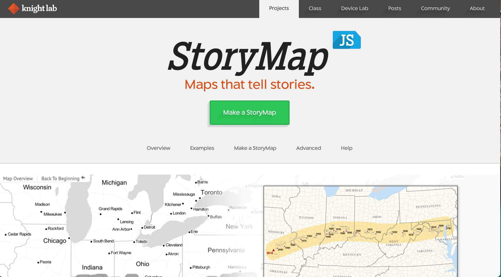
Weird. Yeah, no, but we hang out we have a good feel good meals and, and fun camaraderie. So it’s good, good. So back to Slate, freezing. It’s snowing here in good ol Wisconsin. True. Those you in warmer climates that Listen, go down here water slides Enjoy, enjoy your time. This week, we are talking about a very cool site. It’s called StoryMap. It is created by night lab. So the website itself is called it’s story map dot knight lab.com. So storymap dot k n i g h t l a b.com. So StoryMap JS maps that tell stories is very cool site. I’m
Fuzz Martin 2:50
a night lab is from Northwestern University. So they’re a community of designers, developers, students and educators working on experiments designed to push journalism into new spaces. I read that if you couldn’t tell
Shanna Martin 3:05
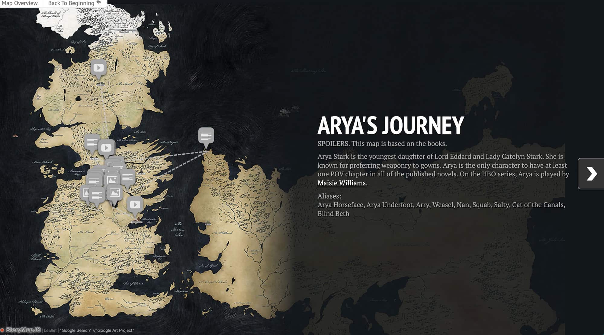
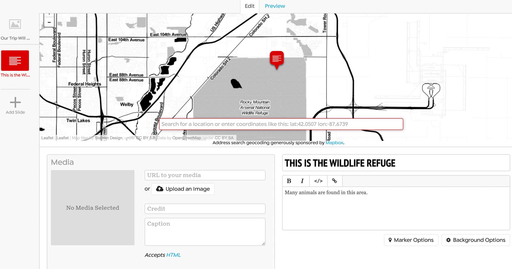
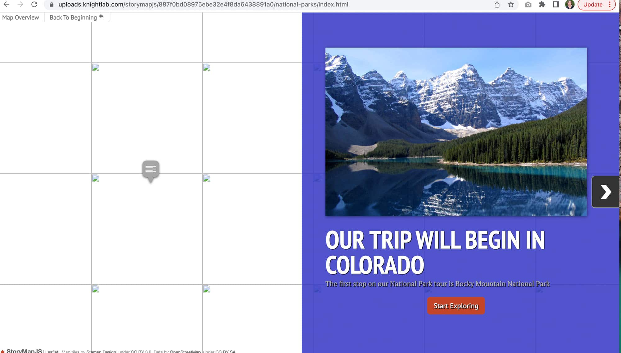
me about tab. So StoryMap is a really cool tool, I’m thinking that fifth grade on up could easily probably in fourth grade at this point and easily manipulate the site all the way through high school. And it’s a way of telling stories, but using maps at the same time, hence the name story map. And it’s really user friendly. So they’ve really cool. They even have like tips and tricks. When you’re setting these up, like keep it short remember, minute note have more than 20 slides, you know, pick your stories have strong locations and narratives. So when you’re telling your story, it’s all within like as a certain place. So that way you’re not bouncing all over the world, a lot of times and Google Earth will do that really flying from one place to another. This is more like if you’re gonna set up the story map of like a vacation, or like a national park in a specific area. Actually, they have an example here, that’s Westeros, which is pretty fantastic. Oh, that’s so you can pull like and literally tell a story with these maps of whatever area, whatever map you kind of load in, so things aren’t necessarily automatic, you do have lots and lots of options. So I’m gonna kind of walk you through here. So there’s like this giant green button, make a story map. It connects to Google, like most things at this point, which is always fantastic. You give it a title. And, and that creates the space and it looks kind of like oh, like where do I go from here. And like the map is black and white. It’s very stark. And again, like I don’t know where to start.
Shanna Martin 4:34
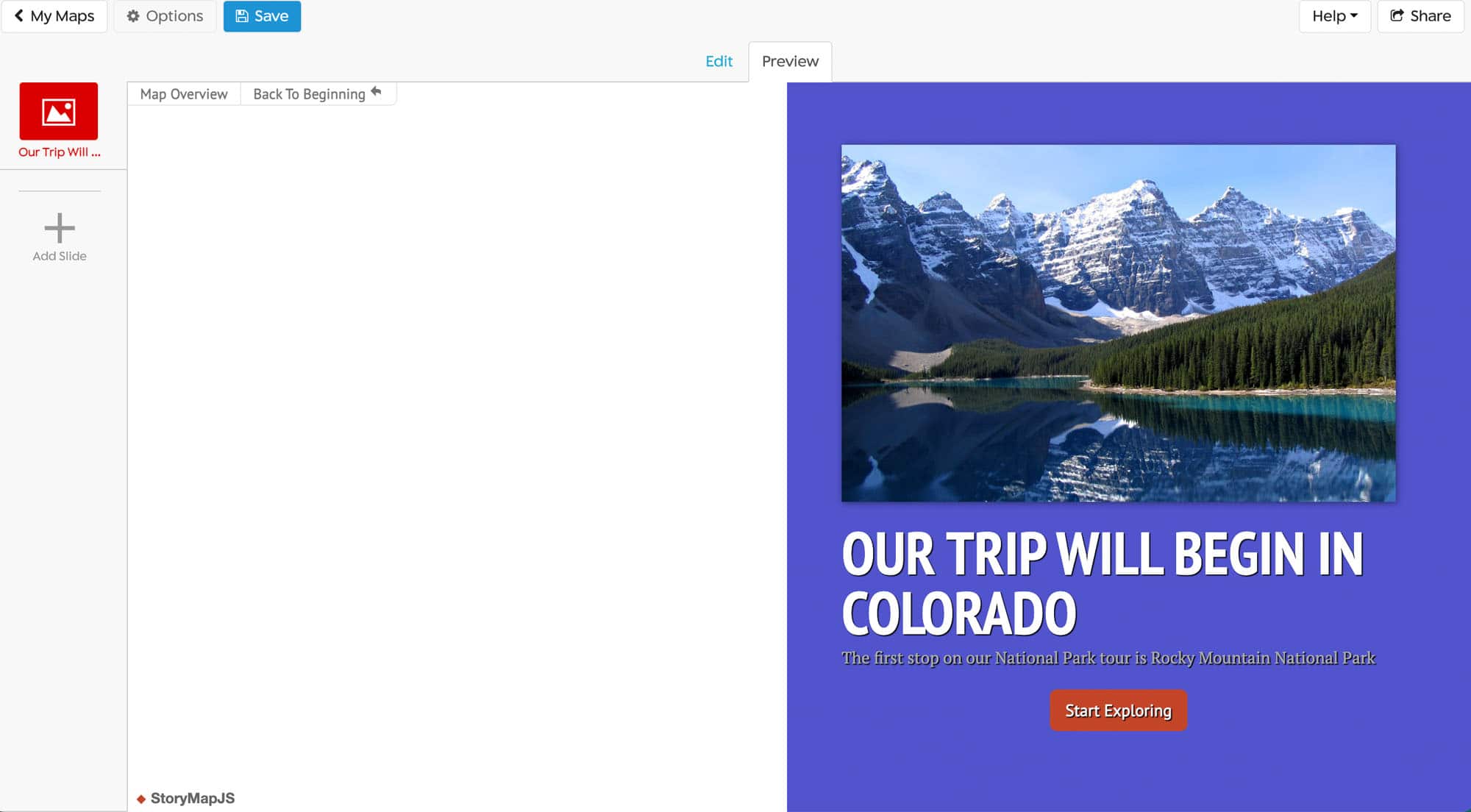
What’s nice is do you have the choice to choose your media so you can select if you’re gonna drop in media from a URL, or if you’re gonna upload an image. So this is like your title page. You can pick if you’re going to, like do a vacation and Disney like pick a family vacation from Disney picture. Drop that image in. Once that uploads into your spot, you can go ahead and give credits captions of whatever it’s going to be. Give it a headline, type in Do you have choices with your fonts and if you want to edit like links into that, you can do so. And you have background options. So like on the bottom right kind of work your way through, you can choose background colors, or you can add a picture. Or you can upload images. And that’s fine too. And that’s just your story slide and it doesn’t look like much when you’re working on it, and click Preview. And then you get a real live version of what your story map starting page would look like. So you kind of like working editing space, and then your preview is where you actually get to see what you’re working on. And then as you add a slide, same thing each time, you can add in your pull up your images, type in your headline, and then tell your story. So if kids are doing this with nonfiction, and they’re walking through a space, like you’re doing a geography lesson, or if you’re doing like a specific park or place, you can type in that research information. Or if students are telling a story or a narrative, maybe they’re writing a story about something in Chicago, and they could take images from Chicago and write a story and put images with it that way, which is really cool. And you just click on a slide, add your information. And you have the same background choices, those marker options, you can choose and add in all kinds of different things, which is awesome, very user friendly,
Shanna Martin 6:14
You do need to click the Save button, which is in the upper left hand side. Then also the upper left hand area where you’re hitting save, if you want to change the size of your map, if you what I really, really appreciate is you can change the language. So if you want your map to read, they have probably over 40 languages that you can work in, which is awesome. So if you want your map to be in Spanish, you can create it in Spanish. If you want it to be in German, if you want it to be in Italian, you can pick and choose what language you want it to be in, you can choose your font. Or you can treat it as a Cartography or an image like you can choose if you want to be a map or an image, you can choose if you want a call to action on it, and then your map type. So you have types of maps that you can work with. They have like black and whites, they have like a watercolor map, they have just a standard like open regular map, and then you can create custom maps. So that’s where you can upload something if you’re pulling like Westeros or something, you can upload that map and then that’s the one that you’re going to work with, which is kind of cool. It shows you where you give credit to everybody who’s created. Yeah,
Fuzz Martin 7:28
the credit and caption there. Yeah, that’s really cool. I am like
Shanna Martin 7:32
you’re playing around with it? Well, I am. So I was thinking of like very serious over there while you’re working on this.
Fuzz Martin 7:37
So we’ve talked about it, I’m sure in one of our previous 134 episodes, but I am the president of the Wisconsin 9/11 Memorial. And a part of our lesson planning is to help create a story of how the steel got from, from the World Trade Center to Wisconsin. And just thinking like this would be a perfect visual for kids to show how the steel got from the World Trade Center. And the journey that it took in order to get to where it’s positioned today.
Shanna Martin 8:08
Yeah, and then you can, when you go to share it, you can just share the link, you can share it on social media or share it with your teacher have a little description with it, and you can share out your information really easily. But there’s so kind of like you talking about the steel getting there, I was thinking about when you brought up in Ireland, memorializing like a tour around the space of memorial like that would be an image where you could like drop in on each of the places or like a tour around your town. Or if you’re teaching community with younger students like learning where things are at in the community, like these are gonna be like local maps or smaller areas, you can definitely you could definitely use a bigger space, but it looks cooler. And it’s easier, I think to understand if you’re working with a smaller, like maybe the state of Wisconsin, sure, you know, that kind of thing. And they do have, like you keep your collection of your little maps. So you can have all your like, they all save like a little dashboard kind of thing. But what’s also nice is that they have example maps too. So if you’re like I don’t know where to start on their homepage, they have all kinds of cool pre created maps, you can say this is how far you can take this project. So you can do really simple or you just have images dropped on a map with the story being told and images added. And you flip through the slides or you can make it way in depth and more detailed and things like that, which is pretty cool.
Fuzz Martin 9:25
Yeah, that’s very cool.
Shanna Martin 9:26
And then it just flips through. So once it’s all loaded in, you hit preview and you can just check in like any kind of slideshow there’s little arrow and use arrow from slide to slide and as your descriptions and your images and then you can click the share button on the right hand side and share it out with whoever you’d like to share your cool story map with love it. So that is story map. I thought it was really cool find and also I’ll probably not talking about this one, not just story map, but I’ll talk about the night lab probably have several times over because there’s all kinds of cool projects They have started and like different ways that you can create and interact. And I think it’s a really neat setup that they have.
Fuzz Martin 10:08
So it’s really cool. It’s the tool itself is wonderful.
Shanna Martin 10:12
Yeah. So StoryMap, check it out. It’s story map dot night lab.com. Again, many, many content areas and many age levels can use this one. And it’s really user friendly and not super complicated. As long as you can type and upload images. You can make a pretty cool story out of the whole thing.
Fuzz Martin 10:30
Yeah, there’s so many possibilities. What a cool tool Shanna. Good work. Cool tool. Cool tools for schools.
Shanna Martin 10:36
Wow. Yeah.
Fuzz Martin 10:37
Well, to be honest, I’m way surprised. That’s the first time I’ve ever said that on the show. That it’s true. Anyway, here we are.
Shanna Martin 10:49
So thanks for tuning in. This has been the tech tools for teachers podcast. If you ever have any questions, you can find me on Twitter at @smartinwi. And if you want to get more information on the links and technology discussed in this episode, you can visit smartinwi.com. If you’d like to support the show, please consider buying me a coffee or to visit buy me a coffee.com/smartinwi or visit smartinwi.com and click on that cute little purple coffee cup. Your donations help keep the show going new episodes each week. Thanks for listening, go educate and innovate.
Fuzz Martin 11:21
The ideas and opinions expressed on this podcast and the smartinwi.com website are those of the author Shanna Martin and not her employer? Prior to using any of the technologies discussed on this episode, please consult with your employer regulations. This podcast offers no guarantee that these tools will work for you as described, but we hope they do